
IRAQ
GEOGRAPHIC CONTEXT & OVERVIEW:
Area:
total: 438,317 km2 (169,235 sq mi)
land: 437,367 km2 (168,868 sq mi)
water: 950 km2 (370 sq mi)
total: 438,317 km2 (169,235 sq mi)
land: 437,367 km2 (168,868 sq mi)
water: 950 km2 (370 sq mi)
Land use:
arable land: 7.89%
permanent crops: 0.53%
other: 91.58% (2012)
arable land: 7.89%
permanent crops: 0.53%
other: 91.58% (2012)
Irrigated land: 35,250 km2 or 13,610 sq mi (2003)
Coastline: 58 km (36 mi)
Maritime claims:
territorial sea: 12 nmi (22.2 km; 13.8 mi) continental shelf: not specified
territorial sea: 12 nmi (22.2 km; 13.8 mi) continental shelf: not specified
Terrain:
mostly broad plains; reedy marshes along Iranian border in south with large flooded areas; mountains along borders with Iran and Turkey
mostly broad plains; reedy marshes along Iranian border in south with large flooded areas; mountains along borders with Iran and Turkey
Elevation extremes:
lowest point: Persian Gulf 0 m
highest point: Cheekah Dar 3,611 m (11,847 ft)
lowest point: Persian Gulf 0 m
highest point: Cheekah Dar 3,611 m (11,847 ft)
Resources and land use:
Natural
resources: petroleum,
natural gas, phosphates, sulfur
Total renewable water
resources: 89.86 km3 or 21.56 cu mi (2011)
Freshwater withdrawal
(domestic/industrial/agricultural):
total: 66 km3/yr (7%/15%/79%)
per capita: 2,616 m3/yr (2000)
total: 66 km3/yr (7%/15%/79%)
per capita: 2,616 m3/yr (2000)
An Introduction to the Natural Resources:

The natural resources of Iraq
are primarily mineral. The country has large reserves of petroleum and natural
gas. Iraq has the second largest oil reserves in the Middle East after Saudi
Arabia. Iraq reports its proven oil reserves at 112 billion barrels, however it
is estimated that there could be an additional 200 billion barrels in
unexplored areas. There are many oil fields scattered across central and
eastern Iraq, but a majority of the oil comes from two major regions; Kirkuk in
the north and Rumaylah in the south. Other than petroleum and natural gas,
there are also small deposits of salt, coal, gypsum, and sulfur.
NATURAL RESOURCES:
·
Land
·
Water
·
Climatic influences
·
Core resource: Oil
·
Flora and Fauna
·
Soils
·
Coral Reef
·
Bibliography and references
LAND
With a land area of 438,446 km2,
the geography of Iraq falls into 4 main regions:
1. The
desert (west of the Euphrates),
2. Upper Mesopotamia (between the upper Tigris and Euphrates rivers),
3. the
northern highlands of Iraqi Kurdistan,
4. Lower Mesopotamia, the
alluvial plain extending from around Tikrit to
the Persian Gulf.
Desert:
The
desert zone, an area lying west and southwest of the Euphrates River, is a part
of the Syrian Desert and Arabian
Desert, which covers sections of Syria, Jordan, Saudi
Arabia and most of the Arabian
Peninsula.
The
region consists of a wide stony plain interspersed with rare sandy stretches. A
widely ramified pattern of wadis–watercourses
that are dry most of the year–runs from the border to the Euphrates. Some wadis are over 400 km (250 mi) long and carry
brief but torrential floods during the winter rains.

Upper Mesopotamia:
The
uplands region, between the Tigris north of Samarra and the Euphrates north of Hit, is known as Al Jazira (the island) and is part of a larger area that
extends westward into Syria between the two rivers and into Turkey. Water in the area flows in deeply cut valleys,
and irrigation is much more
difficult than it is in the lower plain. Much of this zone may be classified as
desert.
Lower Mesopotamia:
An Alluvial
plain beginning north of Baghdad extending to the Persian Gulf, the Tigris and Euphrates rivers lie above the level of
the plain in many places here, and the whole area is a river delta interlaced by the channels of the two rivers and by
irrigation canals.
Intermittent lakes, fed by the rivers in flood, also characterize
southeastern Iraq. Much of it is permanent marsh, but some parts dry out in
early winter, and other parts become marshland only in years of great flood.
Because
the waters of the Tigris and Euphrates above their confluence are heavily silt- laden, irrigation and
fairly frequent flooding deposit large quantities of silty loam in much of the
delta area. Windborne silt contributes to the total deposit of sediments. It has
been estimated that the delta plains are built up at the rate of nearly twenty
centimeters in a century. In some areas, major floods lead to the deposit in
temporary lakes of as much as thirty centimeters of mud.
The
Tigris and Euphrates also carry large quantities of salts. These, too, are spread on the land by excessive
irrigation and flooding. A high water table and
poor surface and subsurface drainage tend to concentrate the salts near the
surface of the soil. In general, the salinity of the soil increases from
Baghdad south to the Persian Gulf and severely limits productivity in the
region south of Al Amarah.
Highlands:
The
northeastern highlands begin just south of a line drawn from Mosul to Kirkuk and
extend to the borders with Turkey and Iran.
High
ground, separated by broad, undulating steppes,
gives way to mountains ranging from 1,000 to 4,000 meters (3,281 to
13,123 ft) near the Iranian and Turkish borders. Except for a few valleys,
the mountain area proper is suitable only for grazing in the foothills and
steppes; adequate soil and rainfall, however, make cultivation possible. Here,
too, are the great oil fields near Mosul and Kirkuk. The northeast is the
homeland of most Iraqi Kurds.
 |
| Ain-Al-Mosul : a master town plan for the development of Mosul |
WATER: The Tigris-Euphrates river system of Iraq
Iraq
is fed by two major rivers, the Tigris and
the Euphrates, both of which originate
outside of Iraq. These two rivers account for 98% of Iraq`s surface water
supply. Their flow is therefore very vulnerable to dams and water
diversions in Turkey, Syria and Iran. The Euphrates does not receive water from
permanent tributaries within Iraq territory and is fed only by seasonal runoff
from wadis. The average annual flow of
the Euphrates at the border to Turkey is estimated at 30 km³, with a
fluctuating annual value ranging from 10 to 40 km³.
The
Tigris has an average annual runoff of 21.2 km³. Within Iraq, the Tigris
River receives water from five main tributaries, namely the Khabour, Great Zab, Little
Zab, Diyala and
Al Authaim. Yet, only the latter lies entirely within Iraq. All together, 50%
of the Tigris water comes from outside the country.
 |
| Tigris-Euphrates river system |
Both the Tigris and the Euphrates break into a number of channels in a marshland area, and the flow of the rivers is substantially reduced by the time they come together at Al Qurnah.

The swamps act as silt traps, and the rivers are relatively silt free as they flow south.
The waters of the Tigris and Euphrates are essential to the life of the country, but they sometimes threaten it. The rivers are at their lowest level in September and October and at flood in March, April, and May when they may carry forty times as much water as at low mark.
 |
| Iraq floods: 2013 |
Rainfall:
 Roughly 90% of the annual
rainfall occurs between November and April, most of it in the winter months
from December through March. The remaining six months, particularly the hottest
ones of June, July, and August, are extremely dry.
Roughly 90% of the annual
rainfall occurs between November and April, most of it in the winter months
from December through March. The remaining six months, particularly the hottest
ones of June, July, and August, are extremely dry.
 Average rainfall is estimated at
 154 mm, with a huge range from less than 100 mm in the south and up to 1200 mm in the north east. This can lead to extensive flooding in central and southern Iraq.
CLIMATE
The climate of Iraq is mainly a hot desert climate or a hot semi-arid climate in the northernmost part. Averages high
temperatures are generally above 40 °C (104 °F) at low elevations
during summer months (June, July and August) while averages low temperatures
can drop to below 0 °C (32 °F) during the coldest month of the year
during winter.
 |
| Extreme heat |
 |
| Extreme cold (recent times)
Temperatures sometimes fall
below freezing and have fallen as low as −14 °C (6.8 °F) at Ar Rutbah
in the western desert. And such summer heat, even in a hot desert, is high and
this can be easily explained by the very low elevations of deserts regions
which experience these exceptionally searing high temperatures.
|
The summer months are marked by two kinds of wind phenomena. The southern and southeasterly sharqi, a dry, dusty wind with occasional gusts of 80 kilometers per hour (50 mph), occurs from April to early June and again from late September through November. It may last for a day at the beginning and end of the season but for several days at other times. This wind is often accompanied by violent duststorms that may rise to heights of several thousand meters and close airports for brief periods.
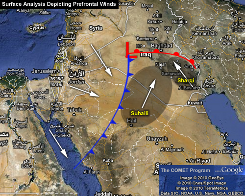 |
| Sharqi wind - April - Early June |
 |
| Sharqi winds - Iraq |
From mid-June to mid-September the prevailing wind, called the shamal, is from the north and northwest. It is a steady wind, absent only occasionally during this period. The very dry air brought by this shamal permits intensive sun heating of the land surface, but the breeze has some cooling effect.
 |
| Shamal winds - mid-June to mid-Sep |
 |
| Shamal Winds - Iraq |
CORE NATURAL RESOURCE: Oil:
Iraq's economy is dominated by the
oil sector, which has provided about 95% of foreign exchange earnings in modern
times. While its proven oil reserves of 112 billion barrels (17.8×10⁹ m3) ranks
Iraq second in the world behind Saudi Arabia, the United States Department of Energy estimates that up to 90 percent of the
country remains unexplored. Unexplored regions of Iraq could yield an
additional 100 billion barrels (16×109 m3).
Iraq's oil production costs are among the lowest in the world.
 |
| Estimated oil extraction - Iraq |
UPSTREAM:
Geologists and consultants have
estimated that relatively unexplored territory in the western and southern
deserts may contain an estimated additional 45 to 100 billion barrels (bbls) of
recoverable oil.
The majority of the known oil
and gas reserves in Iraq form a belt that runs along the eastern edge of the
country. Iraq has 9 fields that are considered super giants (over 5 billion
bbls) as well as 22 known giant fields (over 1 billion bbls). According to
independent consultants, the cluster of super-giant fields of southeastern Iraq
forms the largest known concentration of such fields in the world and accounts
for 70 to 80 percent of the country’s proven oil reserves. An estimated 20
percent of oil reserves are in the north of Iraq, near Kirkuk, Mosul and Khanaqin.
CORE NATURAL RESOURCE: Processed: Petroleum:
Iraq was the world’s 12th largest oil producer in 2009, and
has the world’s fifth largest
proven petroleum reserves after Venezuela, Saudi
Arabia, Canada, and Iran.
Just a fraction of Iraq’s known fields are in development,
and Iraq may be one of the few places left where vast reserves, proven and
unknown, have barely been exploited.
Iraq’s energy sector is heavily based upon oil, with
approximately 94 percent of its energy needs met with petroleum. In addition,
crude oil export revenues accounted for over two-thirds of GDP in 2009.
CORE NATURAL RESOURCE: Processed: Natural Gas:
Iraqi natural gas production
rose from to 81 (billion) Bcf in 2003 to 522 Bcf in 2008. Some is used as fuel
for power generation, and some is re-injected to enhance oil recovery. Over 40
percent of the production in 2008 was flared due to a lack of sufficient
infrastructure to utilize it for consumption and export, although Royal Dutch Shell estimated that flaring losses were even
greater at 1 Bcf per day. As a result, Iraq’s five natural gas
processing plants, which can process over 773 billion cubic feet per year, sit
mostly idle.
FLORA
AND FAUNA
Vegetation is meager throughout
much of Iraq since the southern and western parts of the country are desert
areas. The country also has few trees, except for the date palm, which is
planted and cultivated, and the poplar.
 |
| Date picking |
Among the many animals found in
Iraq are the cheetah, gazelle, antelope, wild ass, hyena, wolf, jackal, wild
pig, hare, jerboa, lizard, and bat. There are also numerous bird species found
in Iraq, including the vulture, buzzard, raven, owl, duck, goose, partridge,
and sand grouse, and various species of hawks.
 |
| Iraqi hyena |
 |
| Jerboa |
 |
| Sand grouse |
SOILS
There are two main types of
soils in Iraq. Heavy alluvial deposits, containing a significant amount of
humus and clay, make up one type and are used for construction. The second main
soil is a lighter soil composed of wind-deposited nutrients. A high saline
content in some areas contaminates the otherwise rich composition of the soils.
Irrigation and flood-control projects on the Tigris and Euphrates rivers help
increase the agricultural production of this area.
CORAL REEF
Iraqi coastal
waters boast a living coral reef, covering an area of 28 km2 in
the Persian Gulf, at the mouth of
the Shatt al-Arab river (29°37′00″N 48°48′00″E).
The
reef harbours several living stone corals, octocorals, ophiuroids and bivalves. There are also silica-containing demosponges.

While
the thought of Iraq having a beautiful coral reef seems a misfit, I was more
than happily surprised to get to know about it.
I
hope you enjoyed reading through as much as I did as well and until next time,
Thank
you!
Bibliography
and References
·
Koeppen Climate Map: http://www.atm.dal.ca/~lohmann/clch/koeppen.jpg
·
Landsat 7: http://landsat.gsfc.nasa.gov/
·
MSN Learning and
Research: http://encarta.msn.com/encnet/features/home.aspx
·
Platts Guide to Iraqi
Oil Industry: http://www.platts.com/features/Iraq/index.shtml
·
The Overland Expedition
Resource: http://www.go- overland.com/stories/1999/sandstorm1.php
·
USDA Crop Explorer: http://151.121.3.218/rssiws/imageview.cfm?regionid=metu&s=change
·
(Platts Guide to Iraqi Oil) (MSN
Learning & Research)
Dear Alifiya, your blog is very informative and educational. you have shed light on something that one wouldn't otherwise consider about these two small countries. the blog is well written and well organised. well done!! :)
ReplyDelete